


Shell River Twp. Voting District, Wadena County, Minnesota
About
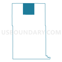
Outline

Summary
| Unique Area Identifier | 604725 |
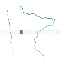
| Name | Shell River Twp. Voting District |
| County | Wadena County |
| State | Minnesota |
| Area (square miles) | 36.11 |
| Land Area (square miles) | 34.90 |
| Water Area (square miles) | 1.21 |
| % of Land Area | 96.65 |
| % of Water Area | 3.35 |
| Latitude of the Internal Point | 46.76866970 |
| Longtitude of the Internal Point | -94.97553010 |
Maps

Graphs
Select a template below for downloading or customizing gragh for Shell River Twp. Voting District, Wadena County, Minnesota


Neighbors
Neighoring Voting District (by Name) Neighboring Voting District on the Map
- Blueberry Twp. Voting District, Wadena County, MN
- Crow Wing Lake Twp. Voting District, Hubbard County, MN
- Hubbard Twp. Voting District, Hubbard County, MN
- Huntersville Twp. Voting District, Wadena County, MN
- Meadow Twp. Voting District, Wadena County, MN
- Orton Twp. Voting District, Wadena County, MN
- Red Eye Twp. Voting District, Wadena County, MN
- Straight River Twp. Voting District, Hubbard County, MN
Top 10 Neighboring County Subdivision (by Population) Neighboring County Subdivision on the Map
- Hubbard township, Hubbard County, MN (784)
- Straight River township, Hubbard County, MN (726)
- Blueberry township, Wadena County, MN (721)
- Red Eye township, Wadena County, MN (490)
- Crow Wing Lake township, Hubbard County, MN (332)
- Shell River township, Wadena County, MN (233)
- Meadow township, Wadena County, MN (217)
- Orton township, Wadena County, MN (204)
- Huntersville township, Wadena County, MN (119)
Top 10 Neighboring Unified School District (by Population) Neighboring Unified School District on the Map
- Park Rapids Public School District, MN (12,088)
- Menahga Public School District, MN (3,617)
- Sebeka Public School District, MN (2,950)
- Nevis Public School District, MN (2,492)
Top 10 Neighboring State Legislative District Lower Chamber (by Population) Neighboring State Legislative District Lower Chamber on the Map
- State House District 4B, MN (41,669)
- State House District 2B, MN (39,744)
- State House District 10B, MN (37,598)
Top 10 Neighboring State Legislative District Upper Chamber (by Population) Neighboring State Legislative District Upper Chamber on the Map
- State Senate District 4, MN (81,148)
- State Senate District 2, MN (76,807)
- State Senate District 10, MN (73,591)
Top 10 Neighboring 111th Congressional District (by Population) Neighboring 111th Congressional District on the Map
Top 10 Neighboring Census Tract (by Population) Neighboring Census Tract on the Map
- Census Tract 4801, Wadena County, MN (3,285)
- Census Tract 705, Hubbard County, MN (2,948)
- Census Tract 707, Hubbard County, MN (2,118)